QLD Western QLD Shire Roads

chartrock

Forum Patriarch
Staff member
Sep 26, 2010
6,156
7,441
113
Gold Coast Hinterland
Currently in Canberra, well almost. At Capital Country CP just outside the ACT border. Rained all night, now some sunshine but the wind would blow a dog off his chain. Decided to have a lay day so I am just laying around.
Drove from Armidale to Burning Mt free camp then to Orange Showgrounds then to Canberra. Roads were dry but broken up something shocking. Playing “dodge the pothole” with 2 tonne of van behind is not easy so I can see a wheel alignment coming up when we get home.
Disappointed that the war memorial is now on restricted access. You have to book a two hour slot to visit and only 4 areas open for viewing, the rest are being renovated.

A couple of pics near Armidale.

6F14FD91-5336-453D-9693-9F7380AE27A4.jpeg

Chandler and Wollomombi Falls on the Waterfall Way

C1505A99-3F1D-4649-98E4-40230D4EFBA8.jpeg

Bakers Creek Falls, Armidale end of the Waterfall Way
 

Drover

Well-Known Member
Nov 7, 2013
12,925
19,697
113
QLD
I'd be running off the major highways to come home, leave the Newell, New England to the puddle jumpers............ far smoother and less traffic drive ....


Western QLD roads would be a horrendous mess by now I imagine.............


Thargomindah Taxi into and out of town ..............bulloo taxi.jpg......... Really the roads closed, Flood Truck is waiting for the water to drop so the SES Boats are doing the food and essential deliveries in and out of town....
 
Last edited:

Drover

Well-Known Member
Nov 7, 2013
12,925
19,697
113
QLD
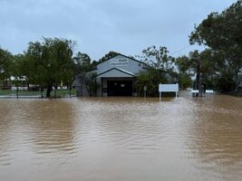
Latest for out Thargomindah way is its still wet, not rain just the Bulloo slowly wandering past, anything west Charleville or Cunnamulla is closed or a bit sketchy at least...... water has dropped enough for the flood truck to run ............some pics of Thargominda today..

East of town Bulloo crossing................Bulloo.jpg ..............................


east of thargo.jpg... Overhead view looking east at the road into town............


Another shot from the east looking into town this time... same road under that water, to the left & right at bottom of pic is the free camp area....
Thargo17-10.jpg ....................... I like that country....
 

Drover

Well-Known Member
Nov 7, 2013
12,925
19,697
113
QLD
Well the touring season is nearly here, Huey has been at it again in one of my favourite areas.......... 31JAN23.
Check with Quilpie and Bulloo Shires........................


QUILPIE SHIRE COUNCIL
Road update 6:00 a.m. 31/01/2023
Lots of rain overnight. Here is what we know so far.
Cooper Developmental Road closed between Eromanga and the Bulloo Shire boundary. There is 0.47 metres of water on the road at Ginniapapa Creek 127 km from Eromanga.
No access to Noccundra and Innamincka from Eromanga.
Water over the road in various locations on the Diamantina Developmental Road between Quilpie and the Cooper Developmental Road turnoff (37 km). The road is open under caution.
A full inspection to the Barcoo Shire boundary heading towards Windorah is underway.
Water on the causeway at Blackwater Creek just outside Adavale but the road is open.
South Comongin Crossing is open . A full Inspection of the Quilpie- Thargomindah Road is underway.
All Shire Roads will be very wet. Please stay off for a day or two to keep the roads in good condition.
 

Hitting the road

Well-Known Member
Jan 14, 2022
234
288
63
Brisbane
Drove the Newell from Goondiwindi to Dubbo, and the Mitchell to Bathurst yesterday. Cunningham to Goondiwindi is good. Plenty of road works going on which slows progress somewhat. Bad section of road going through the Moree bypass where roadworks are underway. Was pelting rain when I sent through so the road will likely be more cut up...plenty of big pot holes to wreak havoc on suspension and tyres...and even big ridges in the centre of the road in some places...
 

Drover

Well-Known Member
Nov 7, 2013
12,925
19,697
113
QLD
Newell is usually like that I found... since I once got paid to drive it I don't drive it unless I'm paid.. ;) ........
If heading down that way I will turn off the Cunningham before Inglewood and rip thru Texas, down to Warrialda, Manilla,Gunnedah, Dunneedoo then join the Mitchell at Wellington, missing the traffic, the crappy Hwy with the bonus of better fuel prices, better road and a wider selection of places to camp if wanted ........ while I think its quicker I can take 3 weeks ........:becky:


QUILPIE SHIRE still damp. UPDATE: 01/02/23 0900

The Quilpie Thargomindah Road has water on the approaches to South Comongin Crossing at The Bulloo River . There is also water on the road at Possamunga turnoff. Drive with care.
The Quilpie Adavale Red Road is closed at Blackwater Creek due to flooding. You can travel up to 70 km from Quilpie before the road is closed but there is no access to Adavale and to Blackall beyond that from Quilpie.
Wareo Road is closed due to a large washout. Repairs will take place tomorrow weather permitting.
Congie Road is also damaged and is closed until repairs can be done.
The Cooper Developmental Road Eromanga to the Bullo Shire boundary remains closed.
The Diamantina Developmental Road is closed from 37.5 km to the Barcoo Shire boundary. Inspectors are checking at present........................................


Its gonna be green....................................
 

Drover

Well-Known Member
Nov 7, 2013
12,925
19,697
113
QLD
Anyone looking at heading to The Big Red Bash and taking their time over the next couple of weeks had better keep an eye on the various state traffic reports, lots of roads out at the moment and this time of year some will need more than 3 weeks to come good so plan ahead. .....

SA: https://www.dit.sa.gov.au/OutbackRo...Q79JY8mB-kkmY8IZnv20jMsSBxLZwkvyoF_zan49rYj3w

NSW: https://www.livetraffic.com/?fbclid=IwAR0c4yXkmm-2QusS7z1N5W0rszEss6CZXm-sjb_xs3J-QaTmHIeWpmO8SfU

QLD: https://qldtraffic.qld.gov.au/
 

Drover

Well-Known Member
Nov 7, 2013
12,925
19,697
113
QLD
Well water, water everywhere, the usual State Traffic sites are working well and also for river heights a couple of updates, for NSW they did away with the very good App they had awhile ago, its replacement is a web page which isn't too bad but a bit clunky .... https://waterinsights.waternsw.com.au/11985-gwydir-regulated-river/updates ........ QLD has a very cumbersome web page for river heights etc but they also have an App that works very well so long as you know the locations, used in conjuction with google Maps its really easy.......... https://water-monitoring.information.qld.gov.au/mobile/
 

Drover

Well-Known Member
Nov 7, 2013
12,925
19,697
113
QLD
Well western QLD and western NSW are certainly places to be sitting tight and not travelling, a tad damp with Nocundra Pub having 15mm, enough to stop movements.

Also a new radar near Crows Nest is running tests soon to be fully operational, named Toowoomba Radar.....
 
  • Like
Reactions: Boots in Action